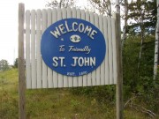
St John
Discover a gem of rural living along Maine's Canadian border.
Weather in St John
Loading the forecast…
 Your logo here
This page could be sponsored
Your business name here
Sponsor This Page
St. John Plantation is located in Aroostook County, Maine, situated along the banks of the Saint John River. It had a recorded population of 263 residents during the 2020 census.

St. John Plantation is a rural community situated in northern Aroostook County, Maine, along the southern bank of the Saint John River, which serves as the international border with the Canadian province of New Brunswick. For visitors traveling to St John Maine, the community covers 51.5 square miles, including 50.3 square miles of land and 1.3 square miles of water, with an elevation of 1,073 feet above sea level. It borders Fort Kent to the east, Saint Francis to the west, and Wallagrass to the southeast.
Community and Local Services
The municipal office is located at 1774 St. John Road, and the plantation is served by ZIP code 04743. In 2024, the community had an estimated population of 180 residents and a median age of 55.7 years. St. John Plantation relies on nearby communities and regional agencies for several municipal services. Fire and rescue coverage is contracted through the Fort Kent Fire and Rescue Department, while police services are provided by the Maine State Police and the Aroostook County Sheriff's Office. Although the plantation does not have its own municipal public library, residents and visitors can access public libraries in neighbouring Allagash and Fort Kent.
Education
Saint John Plantation belongs to Maine School Administrative District #27 (MSAD 27), alongside Fort Kent, New Canada, Saint Francis, and Wallagrass. Students attend Fort Kent Elementary School (grades PreK–6), Valley Rivers Middle School (grades 7–8), and Fort Kent Community High School (grades 9–12) in nearby Fort Kent. Career and technical training is available at the St. John Valley Technology Center in Frenchville. Fort Kent also hosts the nearest public higher education institution, the University of Maine at Fort Kent.

Transportation and Travel
Maine State Route 161 (St. John Road) is the main highway running through the plantation along the river, connecting about 10 miles east to Fort Kent and southwest toward Saint Francis and Allagash. Route 161 is designated as part of the St. John Valley Cultural Byway, which extends between Hamlin and Allagash. St. John Plantation is also one of five municipal owners of the Northern Aroostook Regional Airport Authority, which runs the Northern Aroostook Regional Airport in neighboring Frenchville.
Outdoor Recreation and Public Lands
The plantation offers several public outdoor spaces and waterways:
- Public Reserved Lands: The community contains two parcels of Maine Public Reserved Lands encompassing 1,167 acres, managed under Maine's Northern Aroostook Region Management Plan.
- Saint John Valley Heritage Trail: A section of this 16.9-mile multi-use trail follows the former Fish River Railroad corridor parallel to Route 161 between Fort Kent and St. Francis.
- Lakes: Water bodies within the plantation include Wheelock Lake in the northeast, Hunnewell Lake in the west, and Wallagrass Lakes (Lakes 1 and 2) in the southeast.
Local Landmarks and Culture
Along St. John Road, landmarks include the St. John Catholic Church, a wood-frame Colonial Revival building designed by architect Aimé Pelletier and constructed between 1909 and 1911; it was listed on the National Register of Historic Places in 2003. Another historic property is the Roosevelt School, built in the early 1920s along Route 161, which stands as the only surviving historic schoolhouse in the plantation and is listed on the National Register of Historic Places. The community also maintains the St. John Historical Society on Route 161. Local businesses and tourism in the area receive regional support from the Greater Fort Kent Area Chamber of Commerce.

History of St John
Originally formed from Township Number 17, Eighth Range West of the Easterly Line of the State (T17 R8 WELS), the township was surveyed in 1849. Settled and organized along the Saint John River during the mid-1800s, St. John Plantation saw lumbermen from Maine's Kennebec Valley among its earliest settlers, while agriculture served as a primary source of employment.
Warrants for its organization were issued in 1859, and the organization of the plantation was officially confirmed in 1870. Decades later, the parish of St. John Vianney was formally established in 1930.
See the history facts and their sources in Quick facts below.
Quick facts
·
Population
- 2000 Census Households
- At the 2000 census, there were 110 households in the plantation, with an average household size of 2.56.[1]
- 2020 Census Population
- St. John Plantation had a population of 263 according to the 2020 U.S. Census.[1]
- 2020 Census Population
- The population of St. John Plantation was 263 at the 2020 census.[1]
- 2020 Census Population
- At the 2020 decennial census, the population of St. John Plantation was 263.[1]
- 2024 Population Estimate
- According to U.S. Census Bureau data reported by Data Commons, the population of St. John Plantation was 180 in 2024.[2]
- Historical Population (2000 to 2010)
- Between 2000 and 2010, the plantation's population dropped from 282 to 267, a decline of 5.3%.[1]
- Median Age
- The median age of residents in St. John Plantation was 55.7 years in 2024.[2]
- Population Change (2010 to 2020)
- The population of St. John Plantation decreased from 267 in 2010 to 263 in 2020, representing a decline of approximately 1.5%.[1]
History (7)
- Early Settlers
- Among the earliest settlers in St. John Plantation were lumbermen from Maine's Kennebec Valley.[3]
- Mid-19th Century Settlement and Economy
- St. John Plantation was settled and organized along the Saint John River during the mid-1800s, with agriculture serving as a primary source of employment.[4]
- Original Township Designation
- Saint John Plantation was formed from Township Number 17, Eighth Range West of the Easterly Line of the State (T17 R8 WELS).[5]
- Parish Establishment
- The parish of St. John Vianney in St. John Plantation was formally established in 1930.[3]
- Plantation Organization
- Originally formed from Township Number 17, Eighth Range (T17 R8 WELS), the organization of Saint John Plantation was officially confirmed in 1870.[5]
- Settlement and Economy
- St. John Plantation was settled and organized in the mid-1800s alongside the St. John River, historically centered on agriculture.[6]
- Survey and Organization Dates
- The township was surveyed in 1849, warrants for its organization were issued in 1859, and its organization as a plantation was confirmed in 1870.[5]
Government (1)
- ZIP Code
- St. John Plantation is served by ZIP code 04743.[1]
Schools (5)
- District Public Schools
- MSAD 27 operates Fort Kent Elementary School (grades PreK–6), Valley Rivers Middle School (grades 7–8), and Fort Kent Community High School (grades 9–12), all located in neighbouring Fort Kent.[7]
- Historic Roosevelt School
- The Roosevelt School, built in 1920 along Maine State Route 161 in Saint John Plantation, was used as a public school until 1969 and was listed on the National Register of Historic Places in 1992.[8]
- Public University
- The nearest public institution of higher education is the University of Maine at Fort Kent, a campus of the University of Maine System located in neighbouring Fort Kent.[9]
- Regional Career and Technical Education Center
- Students in MSAD 27 have access to career and technical programs at the St. John Valley Technology Center, located nearby in Frenchville.[7]
- School District
- Saint John Plantation is part of Maine School Administrative District #27 (MSAD 27), which also includes Fort Kent, New Canada, Saint Francis, and Wallagrass.[10]
Economy (3)
- Local Land Use and Economic Development Policy
- Commercial rezoning in St. John Plantation falls under Maine's Land Use Planning Commission comprehensive planning framework, which requires economic development projects to align with local economies and utilize rural infrastructure efficiently.[11]
- Public Lands Resource Management
- St. John Plantation is included in Maine's Northern Aroostook Region Management Plan administered by the Bureau of Parks and Public Lands to balance natural resource conservation, public recreation, and forestry assets.[12]
- Regional Chamber of Commerce Coverage
- St. John Plantation is part of the service area of the Greater Fort Kent Area Chamber of Commerce, which supports regional business, tourism development, and networking across upper Aroostook County communities.[13]
Landmarks (2)
- St. John Catholic Church architecture and construction
- Built between 1909 and 1911 to designs attributed to architect Aimé Pelletier, St. John Catholic Church is a wood-frame Colonial Revival church situated along the Saint John River corridor.[14]
- St. John Catholic Church listing on the National Register of Historic Places
- St. John Catholic Church on St. John Road in St. John Plantation was listed on the National Register of Historic Places in 2003.[15]
Recreation (3)
- Lakes in St. John
- Lakes located within St. John Plantation include Wheelock Lake in the northeast, Hunnewell Lake in the west, and Wallagrass Lakes (Lakes 1 and 2) in the southeast.[16]
- Maine Public Reserved Lands
- St. John Plantation hosts two parcels of Maine Public Reserved Lands totaling 1,167 acres.[16]
- Saint John Valley Heritage Trail
- A section of the 16.9-mile multi-use Saint John Valley Heritage Trail passes along the former railroad corridor near St. John Road between Fort Kent and St. Francis.[16]
Culture (5)
- Acadian settlement heritage
- St. John Plantation was originally settled by Acadian French in the late eighteenth and early nineteenth centuries.[17]
- Historical society
- The community maintains a local historical organization known as the St. John Historical Society, based along Route 161 (St. John Road).[18]
- Maine Acadian folklife survey
- French American and Acadian cultural traditions and architecture in St. John Plantation were documented as part of the American Folklife Center's 1991 Maine Acadian Folklife Survey.[19]
- Roosevelt School historic landmark
- Built in the early 1920s to educate grades 1 through 5 until 1969, the Roosevelt School is listed on the National Register of Historic Places and is the only surviving historic schoolhouse in St. John Plantation.[17]
- St. John Valley cultural byway
- St. John Plantation is situated along the St. John Valley Cultural / Fish River National Scenic Byway corridor, which commemorates the heritage of Maine Acadians, French Canadians, Scotch-Irish settlers, and Maliseet and Mi'kmaq peoples.[20]
Transportation (5)
- Distance to Fort Kent
- St. John Plantation is situated approximately 10 miles west of Fort Kent along Route 161.[21]
- Former rail corridor trail connection
- The St. John Valley Heritage Trail follows the former Fish River Railroad corridor for 16.9 miles between Fort Kent and St. Francis, passing through St. John Plantation parallel to Route 161.[22]
- Ownership of Northern Aroostook Regional Airport
- St. John Plantation is one of five owner municipalities of the Northern Aroostook Regional Airport Authority, which operates Northern Aroostook Regional Airport in neighboring Frenchville.[23]
- Primary highway route
- Maine State Route 161 (St. John Road) serves as the primary thoroughfare running through St. John Plantation along the Saint John River, connecting it east to Fort Kent and southwest toward St. Francis and Allagash.[24]
- Scenic byway designation
- Route 161 through St. John Plantation forms part of the St. John Valley Cultural Byway, which extends along northern Maine between Hamlin and Allagash.[25]
Services (4)
- Fire and Rescue Coverage
- Saint John Plantation does not have its own fire department and contracts for fire and rescue services through the Fort Kent Fire and Rescue Department.[26]
- Municipal Office
- The municipal office for Saint John Plantation is located at 1774 St. John Road in St. John Plantation, Maine.[27]
- Police Services
- Police coverage in Saint John Plantation is provided by regional law enforcement agencies, including the Maine State Police and the Aroostook County Sheriff's Office.[28]
- Public Library Availability
- Saint John Plantation does not operate a municipal public library; nearby community libraries include the public library in neighbouring Allagash and library facilities in Fort Kent.[29]
Geography (8)
- Bordering Communities
- Saint John Plantation borders Fort Kent to the east, Saint Francis to the west, and Wallagrass to the southeast, as well as the Canadian province of New Brunswick across the Saint John River.[5]
- Bordering River
- Saint John Plantation lies along the southern bank of the Saint John River, which forms the international border between the United States and Canada.[30]
- County and River Location
- St. John Plantation is located in Aroostook County, Maine, along the banks of the Saint John River.[1]
- Elevation
- Saint John Plantation has an elevation of 1,073 feet above sea level according to University of Maine Cooperative Extension records.[31]
- Location within Aroostook County
- Saint John Plantation is located in northern Aroostook County, Maine, situated along the Saint John River.[1]
- Total Area
- According to the United States Census Bureau, St. John Plantation covers a total area of 51.5 square miles, consisting of 50.3 square miles of land and 1.3 square miles of water.[1]
- Total Area
- The plantation covers a total area of 51.5 square miles, consisting of 50.3 square miles of land and 1.3 square miles of water.[1]
- Total Area
- Saint John Plantation encompasses a total area of 51.5 square miles (133.5 square kilometers), including 50.3 square miles of land and 1.3 square miles of water.[1]
Map of St John
Nearby communities
All communities in The County
St. John Valley
Central Aroostook
Southern Aroostook
Sources (31)
- St. John Plantation, Maine - Wikipedia — en.wikipedia.org , viewed Oct 9, 2026
- St. John plantation - Data Commons — datacommons.org , viewed Oct 9, 2026
- St.John Plantation — upperstjohn.com , viewed Oct 9, 2026
- St. John - Undiscovered Maine — umaine.edu , viewed Oct 9, 2026
- Saint John Plantation, Aroostook County, Maine Genealogy - FamilySearch — familysearch.org , viewed Oct 9, 2026
- St. John - Undiscovered Maine — umaine.edu , viewed Oct 9, 2026
- Employment Opportunities - Maine School Administrative District #27 — sad27.org , viewed Oct 9, 2026
- Roosevelt School (St. John, Maine) - Wikipedia — en.wikipedia.org , viewed Oct 9, 2026
- General Information - UMFK - UMS - University of Maine System — umfk.edu , viewed Oct 9, 2026
- Maine School Administrative District - Wikipedia — en.wikipedia.org , viewed Oct 9, 2026
- state of maine department of agriculture, conservation & forestry land use planning commission - 45 radar road ashland, maine 04732-3600 - Maine.gov — maine.gov , viewed Oct 9, 2026
- Northern Aroostook: Management Plans: Planning and Acquisition Process: State Parks and Public Lands: Maine ACF - Maine.gov — maine.gov , viewed Oct 9, 2026
- How the Chamber Works - Greater Fort Kent Area Chamber of Commerce — fortkentchamber.com , viewed Oct 9, 2026
- St. John Catholic Church (Saint John Plantation, Maine) - Wikipedia — en.wikipedia.org , viewed Oct 9, 2026
- Maine (U.S. National Park Service) — home.nps.gov , viewed Oct 9, 2026
- St. John - Undiscovered Maine — umaine.edu , viewed Oct 9, 2026
- National Register of Historic Places Registration Form - Roosevelt School — npgallery.nps.gov , viewed Oct 9, 2026
- YVETTE G. PELLETIER Obituary — obituaries.bangordailynews.com , viewed Oct 9, 2026
- Map for the Maine Acadian Folklife Survey Area - Overview - ArcGIS Online — arcgis.com , viewed Oct 9, 2026
- St. John Valley Cultural/Fish River Byway — nsbfoundation.com , viewed Oct 9, 2026
- Pleasant Valley Elderly Housing St. John | St. JohnValleyRealty — stjohnvalleyrealty.com , viewed Oct 9, 2026
- St. John Valley Heritage Trail | Visit Aroostook — visitaroostook.com , viewed Oct 9, 2026
- Northern Aroostook Regional Airport Authority at KFVE - AOPA — aopa.org , viewed Oct 9, 2026
- Maine State Route 161 - Wikipedia — en.wikipedia.org , viewed Oct 9, 2026
- Transportation | NMDC - Northern Maine Development Commission — nmdc.org , viewed Oct 9, 2026
- Fire | FortKent - Town of Fort Kent — fortkent.org , viewed Oct 9, 2026
- Saint John Plt | SOS - Maine.gov — maine.gov , viewed Oct 9, 2026
- Saint John | Maine State Police — maine.gov , viewed Oct 9, 2026
- Public Library Directory by Town - Maine.gov — maine.gov , viewed Oct 9, 2026
- Saint John Plt. | Maine.gov — maine.gov , viewed Oct 9, 2026
- Aroostook County Elevations - Cooperative Extension: Food & Health — extension.umaine.edu , viewed Oct 9, 2026