Perham
An Aroostook County town incorporated in 1897
Weather in Perham
Loading the forecast…
 Your logo here
This page could be sponsored
Your business name here
Sponsor This Page
Located in eastern Aroostook County, Perham was settled in the mid-nineteenth century and officially incorporated in 1897. Named in honor of former Maine Governor Sidney Perham, the town had a population of 371 at the 2020 census.

About Perham, Maine
Perham is an incorporated town located in eastern Aroostook County in northeastern Maine, resting at an elevation of approximately 673 feet (205 meters) above sea level. The town borders Woodland along its eastern boundary. Covering a total area of 36.64 square miles (94.90 square kilometers), the community consists of 36.53 square miles (94.61 square kilometers) of land and 0.11 square miles (0.28 square kilometers) of water.
As of the 2020 Census, Perham had a population of 371 residents. American Community Survey 5-year estimates reported about 134 households with an average of 2.4 persons per household and an estimated median age of 53 years. For labor tracking, the Maine Department of Labor places Perham within the Presque Isle Labor Market Area. The town has an estimated median household income of $62,500, an average per capita income of $38,529, and an estimated poverty rate of 2.45%.
Community Services and Government
The municipal office and clerk services for Perham are located at 206 High Meadow Road, and the town is served by ZIP code 04766. Perham is represented as part of Aroostook County Commissioner District 3. Fire protection services are provided by the neighboring Washburn Fire Department. Local community institutions include the Perham Historical Society, Fairview Cemetery, Perham Baptist Church, and North Star Pentecostal Church.
Schools
Public education is administered through Maine School Administrative District 45 (MSAD #45), also designated as Regional School Unit 45, which serves Perham, Wade, and Washburn. Perham holds two director seats on the governing school board. The superintendent's office is located at 33 School Street in Washburn. Elementary students attend David J. Lyon Washburn Elementary School at 33 School Street, while secondary students attend Washburn District High School at 1359 Main Street in Washburn.

Outdoor Recreation
Visitors exploring Perham Maine will find several natural features and recreational trails. The town is traversed by streams including West Branch Salmon Brook, Factory Brook, and Caribou Stream. Drainage flows through Salmon Brook into the Salmon Brook Lake Bog wetland system.
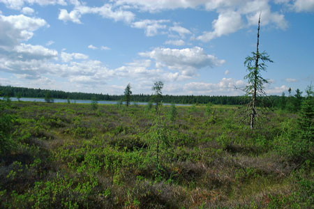
The Salmon Brook Lake Bog Public Reserved Land spans 1,857 acres in Perham, featuring a 1,053-acre state ecological reserve and northern white cedar wetlands. Within the reserve, a 4.7-mile trail network crosses dirt, gravel, and bog boardwalks for hiking, nature study, and wildlife watching. A day-use area along the trails includes a picnic shelter and hand-carry boat access to Salmon Brook Lake, a shallow 51-acre water body.
In addition, the Bangor and Aroostook Trail runs directly through Perham, offering year-round multi-use trail access for hiking, bicycling, ATVs, and snowmobiles.
Transportation
Maine State Route 228 is the primary highway passing through Perham, linking the town southwest toward Washburn and east toward Woodland and Caribou. The Maine Department of Transportation maintains Route 228, with highway paving scheduled under the 2026–2028 Work Plan, and allocated $29,344 in Local Road Assistance Program funding to Perham for fiscal year 2026.
Public transit and demand-response rides are provided by Aroostook Regional Transportation Systems (ARTS). For air travel, Caribou Municipal Airport provides public aviation in neighboring Caribou, while commercial flights operate out of Presque Isle International Airport in Presque Isle.

History of Perham
In 1845, Massachusetts sold the standing timber rights on Township 14, Range 4, to John Goddard of Orono, an arrangement that led to later disputes with early settlers. Settlement began in the mid-nineteenth century, and in 1860, the State of Maine surveyed the township into 160-acre lots for people to settle. As the area developed, Maine's historic Swedish Colony expanded across several Aroostook County communities, taking in territory and historic sites within Perham.
Originally organized as Perham Plantation, the community was officially incorporated as the town of Perham by an act of the Maine Legislature in 1897. The town received its name in honor of Sidney Perham, who served as the 33rd Governor of Maine.
See the history facts and their sources in Quick facts below.
Quick facts
·
Population
- 2010 Census Households
- According to the 2010 decennial census, there were 151 households living in Perham.[1]
- 2010 Median Age
- The median age of residents in Perham was 45.3 years as recorded in the 2010 census.[1]
- 2020 Census Population
- The town of Perham had a population of 371 according to the 2020 Decennial Census.[1]
- 2020 Decennial Census Population
- At the 2020 United States Census, Perham had an official population count of 371 residents.[1]
- American Community Survey Households
- American Community Survey 5-year data reported an estimated 134 households in Perham, with an average of 2.4 persons per household.[2]
- American Community Survey Median Age
- According to the Census Bureau's American Community Survey 5-year estimates profiled by Census Reporter, Perham's median age was estimated at 53 years.[2]
- Population Change (2010 to 2020)
- Between the 2010 census and the 2020 census, Perham's population decreased from 386 to 371, reflecting a 3.9% decline.[1]
History (6)
- Incorporation
- Perham was settled in the mid-nineteenth century and officially incorporated in 1897.[3]
- Settlement and Survey
- Township 14, Range 4 (later Perham) was surveyed into 160-acre lots for settlement by the State of Maine in 1860.[4]
- Swedish Colony Heritage
- Maine's historic Swedish Colony expanded across several Aroostook County communities, encompassing territory and historic sites within Perham.[5]
- Timber Dispute
- In 1845, Massachusetts sold the standing timber rights on Township 14, Range 4 (Perham) to John Goddard of Orono, which led to subsequent disputes with early settlers.[4]
- Town Incorporation
- Formerly organized as Perham Plantation, the town of Perham was officially incorporated by an act of the Maine Legislature in 1897.[6]
- Town Namesake
- The town of Perham was named in honor of Sidney Perham, who served as the 33rd Governor of Maine.[5]
Government (1)
- ZIP Code
- The municipal office and community of Perham are served by ZIP code 04766.[7]
Schools (5)
- District Central Administration
- The superintendent's office for MSAD #45 is located at 33 School Street in Washburn, Maine.[8]
- District Elementary School
- Elementary public school students in the district attend David J. Lyon Washburn Elementary School, located at 33 School Street in neighboring Washburn.[8]
- District High School
- Secondary public school students in the district attend Washburn District High School, located at 1359 Main Street in neighboring Washburn.[8]
- School Board Representation
- Perham holds two director seats on the MSAD #45 / RSU 45 governing school board.[9]
- School District Membership
- The town of Perham is part of Maine School Administrative District 45 (MSAD #45), also designated as Regional School Unit 45, which serves the member communities of Perham, Wade, and Washburn.[8]
Economy (6)
- Historical Founding Industry
- Settlement began in 1860, and Perham was historically recognized as having lumber and logging as its main early industry.[10]
- Labor Market Area Classification
- The Maine Department of Labor designates Perham as part of the Presque Isle Labor Market Area for economic and labor force tracking.[11]
- Local Road Assistance Funding
- Perham was allocated $29,344 in Local Road Assistance Program funding for fiscal year 2026 by the Maine Department of Transportation.[12]
- Median Household Income
- The median household income in Perham was estimated at $62,500.[13]
- Per Capita Income
- The town of Perham had an average per capita income of $38,529.[13]
- Poverty Rate
- The estimated poverty rate in Perham is 2.45%.[13]
Landmarks (4)
- Fairview Cemetery
- Fairview Cemetery is a historic town burial ground located in Perham.[14]
- Historic Swedish Colony Sites
- Perham was part of northern Maine's historic Maine Swedish Colony settlement area, which extended across neighboring towns like New Sweden, Woodland, Stockholm, and Westmanland.[15]
- North Star Pentecostal Church
- The North Star Pentecostal Church in Perham originated informally during the 1950s in the former North Star School building and was formally incorporated in 1970.[16]
- Perham Baptist Church
- The Perham Baptist Church originated as a branch of the Washburn church in 1889 and became an independent congregation in 1890.[16]
Recreation (5)
- Bangor and Aroostook Multi-Use Trail
- The Bangor and Aroostook Trail passes directly through Perham, providing year-round multi-use recreational access for hiking, bicycling, ATVs, and snowmobiles.[5]
- Local Waterways
- The town of Perham is traversed by waterways including West Branch Salmon Brook, Factory Brook, and Caribou Stream.[17]
- Salmon Brook Lake Boating Access
- A day-use site along the reserve's trail network features a picnic shelter and hand-carry boat access to the shallow 51-acre Salmon Brook Lake.[18]
- Salmon Brook Lake Bog Public Reserved Land
- Salmon Brook Lake Bog Public Reserved Land in Perham spans 1,857 acres, featuring a 1,053-acre state ecological reserve and northern white cedar wetlands.[19]
- Salmon Brook Lake Bog Trail Network
- A 4.7-mile trail network runs through the reserve over dirt, gravel, and bog boardwalks, providing access for hiking, nature study, and wildlife watching.[18]
Culture (4)
- Historical Naming Origin
- The town of Perham was settled in the mid-nineteenth century, incorporated in 1897, and named after former Maine Governor Sidney Perham.[3]
- Local Historical Society Organization
- The Perham Historical Society is a nonprofit organization established in Perham to support local historical and cultural preservation.[20]
- Maine Swedish Colony Regional Heritage
- Perham is historically recognized as part of the Maine Swedish Colony area, a region in Aroostook County where Swedish settlement expanded following the founding of neighboring New Sweden in 1870.[21]
- Olof Nylander Photographic Documentation
- Naturalist and photographer Olof Nylander documented early 20th-century life and landscapes across Aroostook County Swedish communities, including Perham.[22]
Transportation (5)
- Nearest commercial airport
- Commercial air travel serving the region operates out of Presque Isle International Airport in nearby Presque Isle.[23]
- Nearest municipal airport
- Caribou Municipal Airport operates as a public aviation facility in the neighboring city of Caribou.[24]
- Primary state highway
- Maine State Route 228 passes through Perham, linking the town southwest toward Washburn and east toward Woodland and Caribou.[25]
- Regional public transit service
- Public transit and demand-response transportation services are provided to Perham and surrounding Aroostook County communities by Aroostook Regional Transportation Systems (ARTS).[26]
- State road capital planning
- The Maine Department of Transportation maintains Route 228 through Perham, with planned highway paving projects scheduled under the 2026–2028 Work Plan.[27]
Services (3)
- County commissioner representation
- Perham is served by Aroostook County Commissioner District 3.[28]
- Fire protection services
- Fire protection services for the town of Perham are provided by the neighboring Washburn Fire Department.[29]
- Municipal clerk and town office location
- Perham's municipal office and clerk services are located at 206 High Meadow Road.[7]
Geography (9)
- Eastern border
- Perham borders the town of Woodland immediately along its eastern boundary.[30]
- Elevation
- Perham has an elevation of approximately 673 feet (205 meters) above sea level.[1]
- Land area
- Perham contains 36.53 square miles (94.61 square kilometers) of land area.[1]
- Location within Aroostook County
- Perham is an incorporated town located in eastern Aroostook County in northeastern Maine.[31]
- Salmon Brook Lake
- Salmon Brook Lake is a shallow, 51-acre water body located in Perham within the Salmon Brook Lake Bog public reserve lands.[18]
- Streams and wetland drainage
- Perham is drained by Salmon Brook, which flows through the Salmon Brook Lake Bog wetland system.[18]
- Total Area
- Perham encompasses a total area of 36.64 square miles, consisting of 36.53 square miles of land and 0.11 square miles of water.[1]
- Total area
- The town covers a total area of 36.64 square miles (94.90 square kilometers).[1]
- Water area
- Water bodies account for 0.11 square miles (0.28 square kilometers) of Perham's total area.[1]
Businesses in Perham
Map of Perham
Nearby communities
All communities in The County
St. John Valley
Central Aroostook
Southern Aroostook
Sources (31)
- Perham, Maine - Wikipedia — en.wikipedia.org , viewed Oct 11, 2026
- Perham town, Aroostook County, ME - Profile data - Census Reporter — censusreporter.org , viewed Oct 11, 2026
- Perham - Undiscovered Maine — umaine.edu , viewed Oct 11, 2026
- Woodland and Perham History - Maine Swedish Colony — maineswedishcolony.info , viewed Oct 11, 2026
- Perham - Undiscovered Maine — umaine.edu , viewed Oct 11, 2026
- MAINE STATE LEGISLATURE — legislature.maine.gov , viewed Oct 11, 2026
- Perham | SOS - Maine.gov — maine.gov , viewed Oct 11, 2026
- MSAD #45: Home — msad45.net , viewed Oct 11, 2026
- Regional School Units (RSUs) | Department of Education - Maine.gov — maine.gov , viewed Oct 9, 2026
- Towns in northern Aroostook County: history and early settlers - The Upper St. John River Valley — vertexaisearch.cloud.google.com , viewed Oct 11, 2026
- Labor Market Area Definitions Change - Digital Maine — vertexaisearch.cloud.google.com , viewed Oct 11, 2026
- Perham - Maine.gov — vertexaisearch.cloud.google.com , viewed Oct 11, 2026
- Perham town, Maine Population 2026 — vertexaisearch.cloud.google.com , viewed Oct 11, 2026
- Fairview Cemetery in Perham, Maine - Find a Grave — findagrave.com , viewed Oct 11, 2026
- Perham - Undiscovered Maine — umaine.edu , viewed Oct 11, 2026
- Woodland and Perham Today - Maine Swedish Colony — maineswedishcolony.info , viewed Oct 11, 2026
- Perham - Maine.gov — maine.gov , viewed Oct 11, 2026
- Salmon Brook Lake Bog Public Reserved Land - Maine Trail Finder — mainetrailfinder.com , viewed Oct 11, 2026
- Salmon Brook Lake Bog | NRCM - Natural Resources Council of Maine — nrcm.org , viewed Oct 11, 2026
- Perham Historical Society - Nonprofit Explorer - ProPublica — projects.propublica.org , viewed Oct 11, 2026
- Maine's Swedish Colony, July 23, 1870 - Welcome - Valkommen — maineswedishcolony.mainememory.net , viewed Oct 11, 2026
- MAINE HISTORICAL SOCIETY — mainehistory.org , viewed Oct 11, 2026
- Getting to Aroostook — visitaroostook.com , viewed Oct 10, 2026
- Aroostook County Public and Private Airports, Maine — maine.hometownlocator.com , viewed Oct 11, 2026
- Maine State Route 228 - Wikipedia — en.wikipedia.org , viewed Oct 11, 2026
- Public Transit Services in Maine | Maine Department of Transportation - Maine.gov — maine.gov , viewed Oct 9, 2026
- Perham - Maine.gov — maine.gov , viewed Oct 11, 2026
- Commissioners – Aroostook County Maine — aroostook.me.us , viewed Oct 11, 2026
- Fire Department | Town of Washburn, Maine | Aroostook County — washburnmaine.org , viewed Oct 11, 2026
- History - Town of Woodland, ME — woodlandmaine.gov , viewed Oct 11, 2026
- Salmon Brook Lake - Maine.gov — maine.gov , viewed Oct 11, 2026